 Disruptive Proactivity
Reusing cycling infrastructure for non-cyclists in Cambridge
This is the view from my window a few times a day:
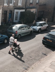
Someone in a wheelchair, or riding a different mobility aid, rolling down the middle of the road because the pavements are too narrow. Cambridge is old, and cycling infrastructure does not just help cyclists, it helps people who are mobility impaired going to other places. Good infrastructure helps everyone.
The Cambridge Cycling Campaign has a helpful tool which allows you to work out the best way to cycle somewhere, called cyclestreets. If you want to get there from anywhere, it’ll tell you the quickest/quietest/mixture way to get there, whichever category you prefer. Underlying that data is knowledge is the Open Street Map, and for Cambridge, the safety of that road for non-motor-vehicles, as a colour sequence: red (worst), yellow, green (best).
While the specific infrastructure is depends on the area, a residential sidestreet can be green without much effort, a designated cycle superhighway can still be a death trap if the “design” is flawed.
Down the road from that example, Cambridge County Council’s principle engineer for highways has approved from a highway perspective a new loading bay where his own assessment says “the delivery driver may concentrate on pulling out into traffic and, with his attention on that issue, may squeeze a pedestrian against the wall of Number 103”.
Good transport infrastructures to get individuals to places should help everyone. It’s nominally a cycling fund, but good cycling infrastructure helps all who move around on non-motorised-vehicles, wheelchairs like steps even less than cyclists do. Cyclists, pedestrians and all should encourage good infrastructure, for where they want to go in their communities.
Visualising cycling and disabled infrastructures
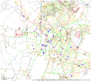
Cambridge’s cycling infrastructure is highly variable, so I’ve put together a nice interactive map, where, using the map of Cambridge, and the button to add the bits of civic amenities of particular interest. It’s clear that that red lines lead to some schools, and the infrastructure to retirement homes is highly variable.
Just click on the category to show what you’re interested in, and you can talk about the infrastructures not for cycling generically, but for cycling based on the other communities that are of interest.
Cambridge generally has comparatively good infrastructure, which reflects it’s comparatively high cycling levels. But as long as the Highways department will attempt flawed designs that it admits are dangerous, there’s still more for everyone interested to do.
Tech parts to do this for other areas
If you want to add your own, the only change to the cyclestreets codebase (which isn’t on github) is line 167-171 of my modified cyclestreets.js. The javascript to add points is derived from the OSM point categorisation, and can also be done for any town you’re interested in…